Enregistrez gratuitement cette image
en 800 pixels pour usage maquette
(click droit, Enregistrer l'image sous...)
|
|
Réf : T02257
Thème :
Terre vue de l'espace - Mers - Côtes - Caps - Péninsules (601 images)
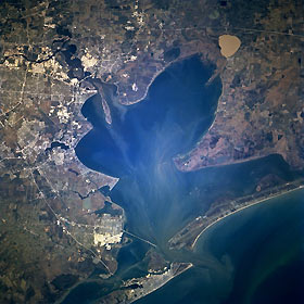
Titre : Galveston Bay and Southeast Houston, Texas, U.S.A. March 1996
Description : (La description de cette image n'existe qu'en anglais)
Galveston Bay, a shallow inlet of the Gulf of Mexico, is featured in this north-northwest-looking, low-oblique photograph. Formed when sea levels rose almost 400 feet (122 meters) as the glaciers melted from the last ice age, the shallow waters cover the former estuaries and river channels of the San Jacinto River and the Trinity River. The present mouth of the Trinity River and sediment-laden, circular Lake Anahuac are visible at the upper end of Trinity Bay (midway between upper center and upper right of the photograph). A portion of the San Jacinto River (upper left) extends into the Houston Ship Channel, whose completion in 1914 enabled the Port of Houston to become the third-busiest in the United States. The highly reflective channel, bordered by numerous oil refineries, petrochemical plants, and other industries, extends southeastward through Galveston Bay into the Gulf of Mexico (bottom right). West of Galveston Bay are Clear Lake and to its northwest Clear Lake City, the home of NASA Lyndon B. Johnson Space Center (barely discernible). Galveston is visible near the bottom center.
|
|

